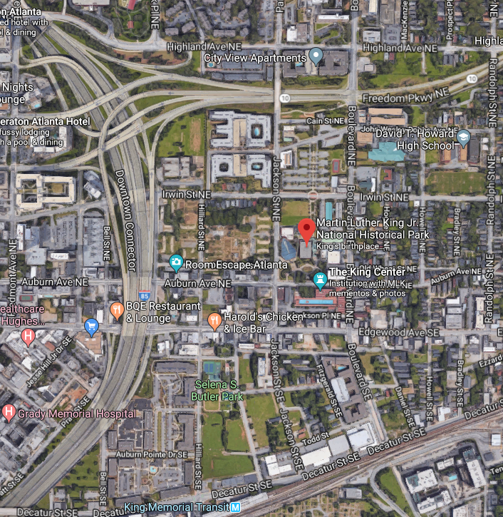
It remains to be seen whether this Martin Luther King Day is more surreal than last the one last year. But in the meantime, we take a virtual trip to downtown Atlanta in the vicinity of the historic and social institutions celebrating Dr. King’s legacy.
The Downtown Connector carries Interstates 75 and 85 through the heart of the city, with downtown Atlanta to the immediate west. Aesthetically, we at CatSynth have a fondness for urban freeways, but we cannot ignore how the adversely affect neighborhoods and displace residents. The Downtown Connector cut the Sweet Auburn neighborhood into two. The historic neighborhood is also bounded by the Freedom Parkway (Georgia State Route 10) to the north, and Blue Line of MARTA to the south, which serves the district via delightfully modernist King Memorial station.
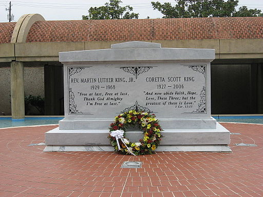
Sweet Auburn is Dr. King’s neighborhood. His childhood home is at 501 Auburn Ave. The Ebeneezer Baptist Church is about a block or so away. The Martin Luther King Jr. National Historic Park covers these and the space in between. On the south side of Auburn Avenue is the King Center (formally, the King Center for Nonviolent Social Change). Martin Luther King Jr’s tomb is on the site. But it is also worth noting that the King Center is not simply a museum, with ongoing research, education programs, and activism.
Many of us are perhaps approaching this day with bated breath, hoping a certain openly racist leader with a tendency to make everything about himself doesn’t make things even worse than they already are. But it might be better to reflect on some of King’s darker words that seem prescient in the moment, such as the Mountaintop Speech or “It’s A Dark Day In Our Nation” (primarily about the Vietnam War). We leave this as an exercise to the reader.
See more of Atlanta and many other fine places across North America in our Highway☆ app, available on the Apple App Store and Google Play Store.
Today our “primary highways” series brings us to the state of North Carolina.
Crossing from Virginia into North Carolina on I-95 (which I most recently did in 2009 under cover of darkness), one gets the sense that “now we are really in the South.” It’s perhaps a combination of the vegetation, terrain, but especially the name “Carolina”.
That particular trip involved traveling southward along I-95, and then later returning to the state near the coast on US 17. The contrast between the different corridors was quite apparent. The US 17 corridor, when when it was not exactly on the coast, was surrounded by shorter vegetation in a lighter shade of green. As we got closer to Wilmington and I-140, it was hard to tell whether we were in a quiet coastal region or in an outer suburb with lots of highways but relatively little visible development. From 17/I-140, we turned onto I-40 and headed north. But if I the time for a proper visit, I would have continued up US 17 back towards the Outer Banks.
One can talk a particularly scenic trip through the Outer Banks on North Carolina Highway 12, which stitches together many of the barrier islands via bridges, causeways and ferries with fantastic views. The road goes through the Hatteras National Seashore. It also goes through Kitty Hawk, often credit as the location of the Wright Brothers’ first flight, though it was actually in nearby Kill Devil Hills. One of the most prominent landmarks, in addition to the continuous stretches of beach, is the Hatteras Lighthouse.
The Outer Banks are part of a beautiful and quite fragile environment, and one that is quite prone to being hit by hurricanes and subject to storm surges and flooding. Consider this breach of the islands and the highway that occurred in 2011.
If we leave the Outer Banks and head northward and eastward on I-40, we eventually come to the Raleigh, the state capital and one of the main cities of the Research Triangle together with Durham and Chapel Hill. The Research Triangle is home many technology companies (both in the Research Triangle Park and beyond), and is anchored by Duke University, University of North Carolina and North Carolina State University. These schools are also known for their basketball teams. Raleigh is a much larger city and the center of state government, and sports both an inner and outer beltway, I-440 and I-540 respectively, though the latter is only partially built. Durham, to the north and west, looks from images as a grittier city that might attract my interest, especially with the old tobacco-factory buildings that have been converted to mixed use.
It is also home to a large and vibrant African American community with a long history of successful businesses and a neighborhood once dubbed “The Black Wall Street.” It was also a center for early Civil Rights activity including some of the earliest “sit-ins.” Already in decline by the late 1960s, the neighborhood appears to have been torn apart by the construction of the Durham Freeway (NC 147) through the center of the city. It is a familiar sounding story (like the Cross Bronx Expressway in New York).
From Durham, I-85 and I-40 run concurrently to the city of Greensboro. Greensboro includes one stretch of I-40 which is signed with no fewer than six different highway numbers.
From Greensboro, we take I-85 south and west towards Charlotte, the state’s largest city. Charlotte has become a major banking center, most notably it is home to “way too big to fail” Bank of America. It has prospered and underwent a major construction boom with a large jumble of post-modern skyscrapers.
The Bank of America headquarters in Charlotte is the “tallest building between Philadelphia and Atlanta.” It is the one with the green lights on top in the photograph above. This sculpture, Arnaldo Pomodoro’s Il Grande Disco sits on Bank of America Plaza. It is known locally as “The Disco Wheel.”
Bank of America is having its shareholder’s meeting this week, and a large protest is expected tomorrow to coincide with the meeting, presumably converging at this very plaza.
We return to Greensboro and head west on I-40. The development becomes sparser and the landscape more hilly and scenic as we approach the Blue Ridge Mountains. And more treacherous as well. We turn onto I-240 to the town of Asheville.
While I have not yet been to Asheville myself, it sounds a little bit like the resort towns here in northern California, with music, arts, and old-style downtown turned upscale, and new-age types. But for me it is most notable as the home of the late Bob Moog, the great synthesizer pioneer and of our heroes at CatSynth. Asheville continues to be the home of Moog Music, Inc, which makes both hardware synthesizers and one of my favorite musical iPad apps, Animoog. The independent but related Bob Moog Foundation is building a museum and cultural space in Asheville, and they are involved in education outreach and teaching students the science and art of electronic music with programs, with specific efforts in western North Carolina.
We conclude by turning north onto I-26, a relatively new and quite spectacular highway through the mountainous border region between North Carolina and Tennessee. The highway, which opened in its current Interstate form in 2003, winds it’s way through mountain passes, alongside cliffs, and even through a tunnel. This video gives a sense of what it is like, even though it is traveling in the opposite direction, from Tennessee back to North Carolina.
This is the interchange of I-85, I-75 and I-20 in Atlanta, GA. No personal significance, though I do like how the incredibly complex curved shapes are bounded by the very rectangular city streets.


 The Downtown Connector carries Interstates 75 and 85 through the heart of the city, with downtown Atlanta to the immediate west. Aesthetically, we at CatSynth have a fondness for urban freeways, but we cannot ignore how the adversely affect neighborhoods and displace residents. The Downtown Connector cut the Sweet Auburn neighborhood into two. The historic neighborhood is also bounded by the Freedom Parkway (Georgia State Route 10) to the north, and Blue Line of MARTA to the south, which serves the district via delightfully modernist King Memorial station.
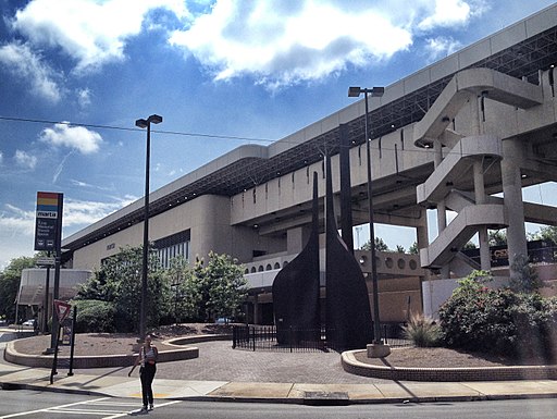
 Crossing from Virginia into North Carolina on I-95 (which I most recently did in 2009 under cover of darkness), one gets the sense that “now we are really in the South.” It’s perhaps a combination of the vegetation, terrain, but especially the name “Carolina”.
 That particular trip involved traveling southward along I-95, and then later returning to the state near the coast on US 17. The contrast between the different corridors was quite apparent. The US 17 corridor, when when it was not exactly on the coast, was surrounded by shorter vegetation in a lighter shade of green. As we got closer to Wilmington and I-140, it was hard to tell whether we were in a quiet coastal region or in an outer suburb with lots of highways but relatively little visible development. From 17/I-140, we turned onto I-40 and headed north. But if I the time for a proper visit, I would have continued up US 17 back towards the Outer Banks.
 One can talk a particularly scenic trip through the Outer Banks on North Carolina Highway 12, which stitches together many of the barrier islands via bridges, causeways and ferries with fantastic views. The road goes through the Hatteras National Seashore. It also goes through Kitty Hawk, often credit as the location of the Wright Brothers’ first flight, though it was actually in nearby Kill Devil Hills. One of the most prominent landmarks, in addition to the continuous stretches of beach, is the Hatteras Lighthouse.

 If we leave the Outer Banks and head northward and eastward on I-40, we eventually come to the Raleigh, the state capital and one of the main cities of the Research Triangle together with Durham and Chapel Hill. The Research Triangle is home many technology companies (both in the Research Triangle Park and beyond), and is anchored by Duke University, University of North Carolina and North Carolina State University. These schools are also known for their basketball teams. Raleigh is a much larger city and the center of state government, and sports both an inner and outer beltway, I-440 and I-540 respectively, though the latter is only partially built. Durham, to the north and west, looks from images as a grittier city that might attract my interest, especially with the old tobacco-factory buildings that have been converted to mixed use.
 It is also home to a large and vibrant African American community with a long history of successful businesses and a neighborhood once dubbed “The Black Wall Street.” It was also a center for early Civil Rights activity including some of the earliest “sit-ins.” Already in decline by the late 1960s, the neighborhood appears to have been torn apart by the construction of the Durham Freeway (NC 147) through the center of the city. It is a familiar sounding story (like the Cross Bronx Expressway in New York).
 From Greensboro, we take I-85 south and west towards Charlotte, the state’s largest city. Charlotte has become a major banking center, most notably it is home to “way too big to fail” Bank of America. It has prospered and underwent a major construction boom with a large jumble of post-modern skyscrapers.

 We return to Greensboro and head west on I-40. The development becomes sparser and the landscape more hilly and scenic as we approach the Blue Ridge Mountains. And more treacherous as well. We turn onto I-240 to the town of Asheville.
 We conclude by turning north onto I-26, a relatively new and quite spectacular highway through the mountainous border region between North Carolina and Tennessee. The highway, which opened in its current Interstate form in 2003, winds it’s way through mountain passes, alongside cliffs, and even through a tunnel. This video gives a sense of what it is like, even though it is traveling in the opposite direction, from Tennessee back to North Carolina.
