


 We begin our tour on US 1 in Coral Gables, where it is known as the South Dixie Highway. I was actually in a pub along here on Election Night 2004, watching the results with friends and colleagues from the International Computer Music Conference (ICMC). For the most part, the election was quite disappointing – and we didn’t even get to enjoy a controversial Florida result to experience first-hand. So after a night of beers and commiseration, we turned our attention back to the conference itself, and to points north. Heading up US 1 towards Miami, we come to the rather unassuming freeway ramp that marks the start of I-95, the main north-south highway along the east coast. It’s a modest beginning for a such a major road. I-95 is an elevated urban highway through downtown Miami, as is the spur I-395 which took us over the city to the MacArthur Causeway and onto Miami Beach as A1A, one of the more oddly numbered highways in the country.
In Miami Beach, A1A continues as Collins Avenue, though the Art Deco district of the South Beach neighborhood.
 [Photo by wyntuition on flickr. Attribution-ShareAlike 2.0 Generic (CC BY-SA 2.0).]
The Art Deco architecture of many of the area’s buildings dates back to the 1920s. One see a certain modernist quality in it, with the details of traditional architectural ornament reduced to simple shapes, but unlike mid-century modernism, such ornament (albeit more abstract) remains. The design of the buildings, the bright colors and the neon lighting are all part of the neighborhood’s character. This was a fun place for food and drink, and to access the beach (it is Miami Beach, after all). The most notable thing about beaches in Florida is that the water is warm, even into the evening. For someone who has lived near beaches in northern California, actually going into the water like this is a bit of a novelty.
 The next day I ventured out on my own using public transit into Miami, primarily using the elevated rail line. I stopped at Calle Ocho (8th Street) and walked its length through the heart of of Miami’s Little Havana neighborhood. The street carries the final section of US 41 towards downtown Miami. I think it was most curious to explore it because of my experience a few years earlier in “Big Havana” (i.e., in Cuba). Probably the main visual feature of the street were the frequent rooster statues along the side, including this somewhat “patriotic” specimen:

By the time I had gotten to downtown, where US 41 terminates at US 1., it had begun to rain. I did make it as far as Bayfront Park where I came upon this sculpture.

North of Miami, I-95 enters the Golden Glades Interchange along with Florida’s Turnpike, FL 826, US 441, and FL 9. As one can see in this photo, it is quite a tangled mess.

[Click to enlarge.]
From here, one can continue north on I-95 along the coast, or veer inland towards Orlando on the Turnpike. We will continue north on I-95, which brings us to Cocoa Beach. This is beach where I first experienced Florida’s atlantic coast as a child, the water, the sand, the seashells. Of course, the reason we stayed here was that it is part of Florida’s “Space Coast” and quite close to Cape Canaveral.

The epicenter of the American space program loomed large in the imagination – even though the moon landings were long over, space was still a powerful draw and the vehicles, structures and devices that made space travel possible were quite exciting to see up close and could even mask the fact that so much of this technology was on the edge and quite inaccessible to most of us. In that sense, space has never really entered into our lives the way computer technology (which also started as remote and rarified) has done so. That is a bit sad. Despite all the joking about a certain presidential candidate’s recent “moon base” proposal, I have to admit I wish we were more ambitious again about expanding into space. We never really solved the problem of efficiently getting into orbit, and thus haven’t been able to make it truly route and accessible. There are those working on this problem, on the Space Coast and elsewhere, but that is a topic for another time.

 As one continues up the coast towards Daytona Beach, I-95 meets I-4, which heads westward and southward through the center of the state. It crosses Florida’s turnpike just south of Orlando and just next to the Walt Disneyworld Resort. Everyone knows Disneyworld. I had last been there as a teenager. EPCOT center was visually interesting (in terms of the buildings and structures), although it was already quite “retro” when it was completed in the 1980s. And the rides were not particularly compelling. I can only imagine it seems very dated now, but that could add to its visual charm.

[Benjamin D. Esham / Wikimedia Commons [CC-BY-SA-3.0-us (www.creativecommons.org/licenses/by-sa/3.0/us/deed.en)], via Wikimedia Commons]
It would be interesting to photograph. But perhaps as interesting from a photography perspective is another, now defunct, theme park just down the road. Splendid China, built and sponsored by the Chinese government, was a theme park that featured scale models of famous Chinese landmarks, including among others a miniature Great Wall. The park was never popular and closed in 2003. Since then, it has fallen into disrepair and is a frequent target of vandalism. I only found out about it as a result of a 2009 exhibition in San Francisco that included photographs by Thomas Cheng documenting the decay.

[Thomas Chang. Great Wall. Splendid China Theme Park, Orlando, Florida.
Image courtesy of the CCC online gallery. Click image to enlarge.]
 I-4 continues southwest towards Tampa Bay, crossing I-75. I-75 is another major north-south national highway, and south of Tampa it largely follows along Florida’s “left coast.” It does, however, abruptly turn and become and east-west highway at the northern edge of the Everglades. This is the famous Alligator Alley. Along this section of I-75 is the Florida Panther Wildlife Refuge, home to the critically endangered Florida panther. There are perhaps around 200 left.

The highway cuts through the panther’s habitat, but the rebuilt version includes passageways underneath for panthers to travel safely. It also facilities the movement of other wildlife. Of course, one does find alligators along the highway.
Returning to the beginning point of our virtual tour, one can travel south on US 1 to the southern tip of mainland Florida, where it becomes the Overseas Highway through the Florida Keys. The highway links together a series of bridges and causeways through the keys.

[Averette at en.wikipedia [CC-BY-3.0 (www.creativecommons.org/licenses/by/3.0)], via Wikimedia Commons]
Some of the structures of this beast were part of an older railroad, and have since been replaced. But old sections remain.

[By Elkman (Own work) [GFDL (www.gnu.org/copyleft/fdl.html) or CC-BY-SA-3.0-2.5-2.0-1.0 (www.creativecommons.org/licenses/by-sa/3.0)], via Wikimedia Commons]
US 1 eventually comes into Key West. It makes a final right turn onto Whitehead Street, passing by the Ernest Hemingway Home and Museum. Among the current residents of the home and museum are “Hemingway’s Cats”, who are descended from the author’s cats and many of whom are polydactyl with extra toes in their paws.

[Averette at en.wikipedia [CC-BY-3.0 (www.creativecommons.org/licenses/by/3.0)], from Wikimedia Commons. Click to enlarge.]
Hemingway was quite fond of these cats, and the museum has become a permanent home for them – we of course hope it stays that way.
Only a few blocks away, US 1 ends. This “end” assembly with Mile 0 marker is probably one of the more photographed ones in existence.

[Photo by CedarBendDrive on flickr. Attribution 2.0 Generic (CC BY 2.0)]
It probably gets stolen quite a bit, too.

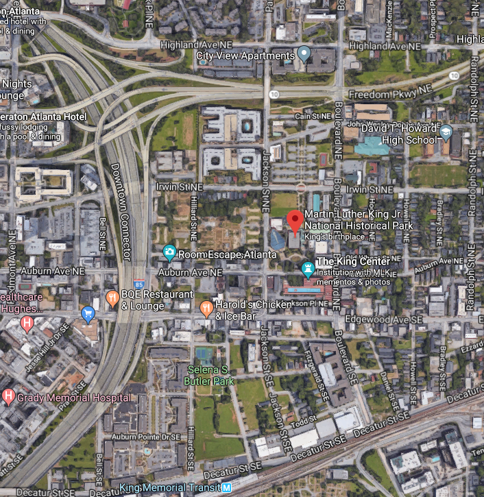


 The Downtown Connector carries Interstates 75 and 85 through the heart of the city, with downtown Atlanta to the immediate west. Aesthetically, we at CatSynth have a fondness for urban freeways, but we cannot ignore how the adversely affect neighborhoods and displace residents. The Downtown Connector cut the Sweet Auburn neighborhood into two. The historic neighborhood is also bounded by the Freedom Parkway (Georgia State Route 10) to the north, and Blue Line of MARTA to the south, which serves the district via delightfully modernist King Memorial station.
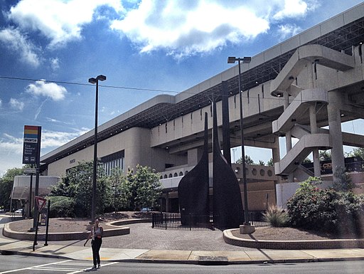
 We begin near Cleveland, the state’s largest metropolitan area. I-90 comes in from the east along the shore of Lake Erie. At “Dead Man’s Curve”, the highway makes an abrupt and rather angular turn to the south to become the Innerbelt Freeway along the edge of downtown.


 The most iconic of the many crossings is the Detroit-Superior Bridge carrying US 6 and US 20 across the river into downtown. The name seems a little odd, as we’re not in Detroit and Cleveland is on Lake Erie rather than Lake Superior. But it connects Detroit Avenue with West Superior Avenue and thus the name is quite appropriate. It rises high above the river and is quite picturesque against the downtown skyline.
 Looking towards the lake from this bridge, one sees how closely packed the crossings are, and the diversity of shape, height, function, and level of disuse. In the picture below, we see the blue bridge carrying a major freeway, State Highway 2, beyond that a rail bridge, and in the front the ruins of the older Detroit Avenue viaduct.


 We depart Cleveland continuing on I-90, and then switch onto I-71 to journey diagonally across the length and breadth of the state. It winds through the suburbs, crossing many other highways before intersecting our friend I-80, which runs across the state as the Ohio Turnpike. The Ohio Turnpike is familiar from numerous cross-country trips, with the rolling hills and suburbs giving way to a much straighter road over flat terrain and farmland as one heads west. But in this instance, we continue south on I-71 towards Columbus, the state’s capital and largest city.


 Columbus is in the middle of the state, and without much to get in the way it has developed the “standard” set of ring roads we see in many cities around the world: an outer beltway (in this case, I-270) and an inner belt around the downtown (a combination of I-70, I-71, I-670 and State Highway 315).


 If instead of going west from airport to Ann Arbor on I-94 we had instead gone east, we would have arrived in Detroit. I have yet to visit Detroit, and as such the city has taken on a mythical quality. I-94 enters the city as the Edsel Ford Freeway, mostly staying to the north of the city center. We can turn south onto I-75, the Chrysler Freeway to head downtown. One would expect the “motor city” to have an impressive network of freeways. I-75 runs along the edge of downtown as the Fisher Freeway, and together with I-375 and Michigan Highway M-10 form a loop around downtown, anchored by some large interchanges on either end.


 But it is time to get back on the road. We can head northwest from Detroit on I-96 to Lansing, the state capital. For those like me who are amused by highway trivia, in Lansing, I-96 and I-69 meet, and even run concurrently for a brief period of time. I think this only place where there is such a mirror-image concurrency (as I-87 and I-78 in New York actually never meet). A spur I-496 turns off into the center of Lansing, with the state capital building to one side.


 North of the bridge, we can switch to US 2 which hugs the shore of Lake Michigan on the southern side of the peninsula. But we can also head inward on M-28, from which we can approach the northern shore along Lake Superior, traveling by many picturesque parks such as Tahquamenon Falls and Pictured Rocks.


